In 1864, the US Army began digging a proper well for Fort Monroe, a Chesapeake Bay Union fort surrounded by then-Confederate Virginia. Three years into the Civil War, and cut off from the state it was built to defend, Fort Monroe had more wounded soldiers and escaped former slaves than it could handle, and its insufficient surface wells had already forced a small-scale “invasion” of Virginia to secure enough water.
After five years of digging (long after the Civil War ended), the Army’s well was 907 feet deep . . . but no matter how deeply they dug, the well was bringing up only saltwater! And salty saltwater, twice as saline as the Atlantic. Subsequent attempts at digging wells also turned up only the same salty brine. The aquifers underground were fed by rain, and sloped down from the inland west; by all rights they should have been salt-free. Yet the salt ran deep and wide, fouling water wells on both sides of the bay.
But why? The US Army in 1860s Virginia certainly didn’t know, nor did anyone else at the time. It would be 114 years later, and 190 miles away, that the first significant clue would finally appear.
The Ship That Studied Stone

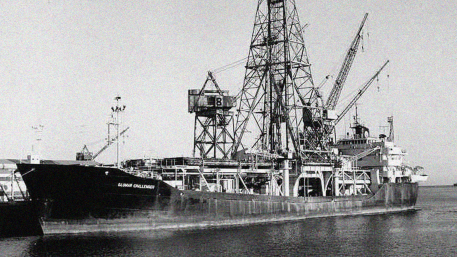
Few oceangoing vessels have been more important to geology than the Glomar Challenger. Launched in 1968 (and named for the Global Marine corporation that owned it) the Challenger was a scientific deep-sea drilling ship, taking core samples of the ocean floor for study.
The Glomar Challenger gave geologists access to seafloor rock that could never have been studied before. Within a few years, the ship (and the scientists on it) had effectively proven seafloor spreading and plate tectonics. The Challenger also provided the first direct evidence that the Mediterranean Sea had dried up (repeatedly), demonstrated the age and composition of ocean plates, revolutionized deep-sea drilling technology and techniques, refined our understanding of plate movement, and much more. Retrieving nearly 100 kilometers of undersea core samples, the Challenger‘s invaluable data catapulted us forward in our understanding of the earth and its oceans.
But by the summer of 1983, the Glomar Challenger—15 years and 90+ scientific expeditions behind it—was scheduled for retirement, to be replaced by a repurposed oil exploration boat. With only a few months of service remaining, the Challenger carried on its mission of scientific discovery, diligently collecting core samples off the New Jersey coast. While seemingly less glamorous than its early expeditions, it was there in the North Atlantic that the Glomar Challenger would surprise the scientific community one last time.
Buried near the edge of the continental shelf, under more than a mile of ocean and 35 million years of sediment, the drill turned up a thin layer of shocked quartz . . . definitive evidence that a previously-undiscovered impact crater was somewhere nearby.
Shock Rocks
For years, evidence had been mounting that a meteor had struck somewhere on earth 35 million years ago. Much of that evidence had been collected by the Glomar Challenger itself. At the close of the 1970s, the ship had found thousands of microtektites (very small droplets of non-volcanic glass) in 35 million-year-old strata beneath the Gulf of Mexico and the Caribbean, which chemically matched 35 million-year-old tektites found as far away as Georgia, Texas, and Massachusetts.
While geologists argued about how chemically-indistinguishable non-volcanic glass came to be spread across an entire continent at the same time (moon volcanoes? alien nuclear bombs?), the Challenger solved the mystery in 1982 by finding a thin layer of iridium just beneath the oceanic microtektites. Iridium—rare on the earth’s surface, not so rare in meteors—was a near-certain sign that there had been a meteor impact, one big enough to fling blobs of molten rock (which cooled to glass in mid-air) from Massachusetts to Texas to the Caribbean.
But the “shocked quartz” was something even more definitive. First identified in the aftermath of underground nuclear tests, geologist and early planetary scientist Eugene Shoemaker noticed the same battered minerals in Meteor Crater, Arizona. Aside from nuclear bombs and meteor impacts, nothing else on earth could generate enough pressure to shock quartz that way, so its presence in the Challenger‘s core samples meant they were, at most, within a few hundred miles of the crater itself.
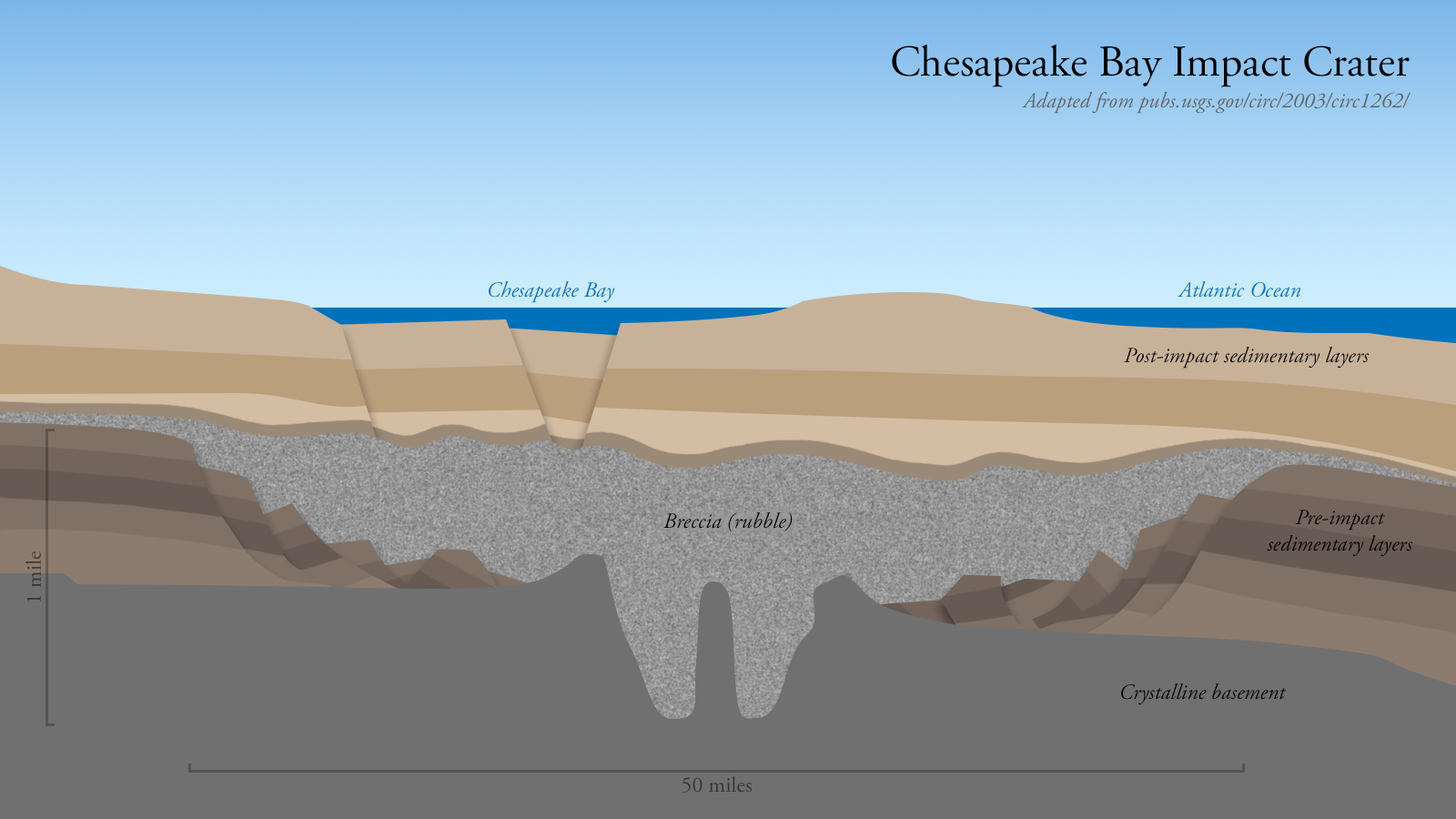
Sadly, the Glomar Challenger‘s part in this story was done. Her final mission complete, the ship was retired and scrapped. Her onboard chief scientist, Dr. C. Wylie Poag, would spend another 10 years searching for the elusive crater, poring over old Challenger seabed cores, seismic data, and data collected by other scientists. Finally, using seismic reflection data shared by Texaco in 1993, he could see it: a 90-kilometer-wide, 35-million-year-old crater buried directly beneath the Chesapeake Bay.
A Twist of Salt

When this Chesapeake meteor slammed into the Atlantic ocean 35 million years ago, it effectively detonated millions of tons of seafloor, flinging shattered and/or molten and/or vaporized rock more than a thousand miles through the air. It also displaced enough water that the subsequent tsunami may have sloshed over the Blue Ridge mountains, a hundred miles inland.
Basically it was a bad day to be living in eastern North America.
The meteor tore through every single layer of sedimentary rock beneath the North Atlantic, cratering all the way into the crystalline basement rock below. One of those sedimentary layers dated back to the very earliest days of the North Atlantic, back to the early Cretaceous, when the continents were still breaking apart, and the baby North Atlantic—warm, shallow, and nearly-landlocked—was twice as salty as the rest of the world’s oceans.
Ancient sediment had trapped a large pocket of that super-salty seawater deep underground for a hundred million years. Not just the salt, but the actual seawater, preserved in its stony tomb for all that time. But when the Chesapeake meteor obliterated all the sediment layers, the pocket of Cretaceous seawater was finally able to escape, ultimately finding its way into the well-water of everybody living around the Chesapeake Bay.
So when those Union Army engineers were digging their well and tasting salt, they were tasting water from an ocean that was 145-100 million years old, water that lapped against North American shores tens of millions of years before the first Tyrannosaurus stalked the earth.
And they were only able to taste a hundred-million-year-old ocean because they were also standing atop one of the largest (and newest) major impact craters on the face of our planet.
Top image: Fortress Monroe camp scene, by George Stacy. 1861-1865. Public Domain, via Library of Congress.

